
Welcome to Orbital Intel, presented by Defense Briefing. Every Wednesday, you receive the week's defense, aerospace and space economy signal in plain language. Primary sources. No hype. Built for analysts, operators and the curious.
Today's headlines are rarely new. They're sequels. We deliver the prequels.
Shijian-31 vs. the Mission Robotic Vehicle: Two Ways to Own GEO
One spacecraft repeatedly crosses above the geostationary belt. The other is embarking on a ten-month climb toward robotic servicing. Their missions reveal two different ways to operate in America's most strategically valuable orbit.
LIVE STATUS, 29-JUL-2026: Shijian-31 launched 16-JUN-2026 on a Long March 3B and is active in its rotated Molniya orbit. The Mission Robotic Vehicle launched 21-JUL-2026 and is raising its orbit under electric propulsion. SpaceLogistics expects roughly ten months to a year of transit before it reaches GEO, so no proximity or servicing operations have occurred.
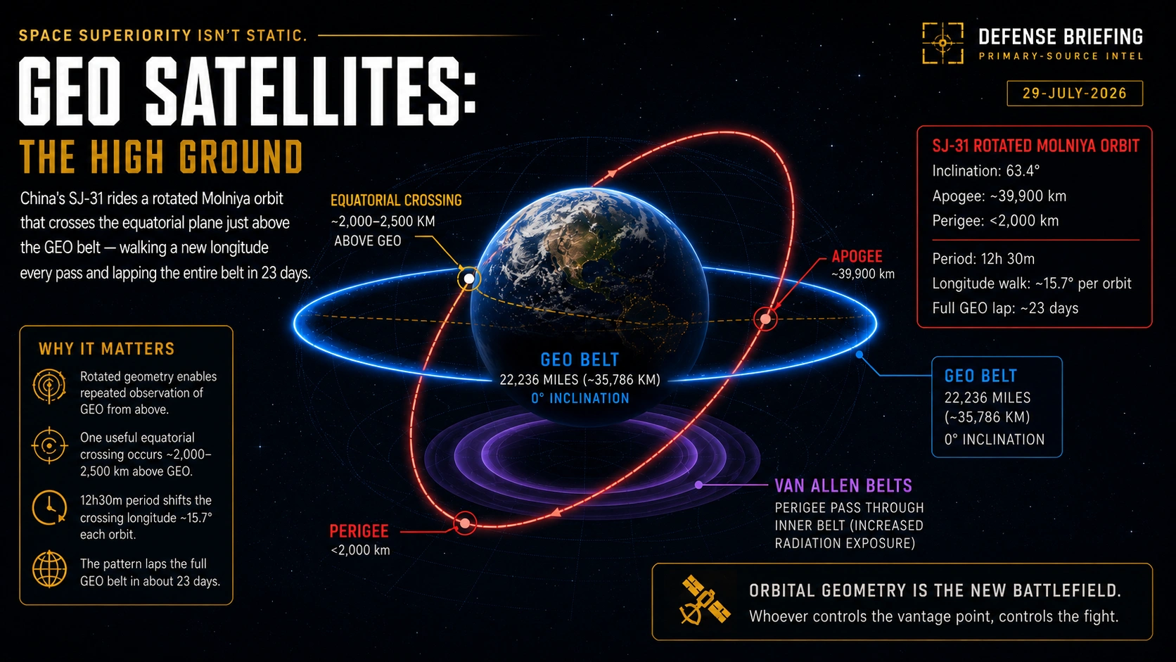
Shijian-31 rides a rotated Molniya orbit whose equatorial crossing sits just above the geostationary belt, walking a new longitude every pass. Graphic: Defense Briefing. Orbital values derived from Integrity ISR analysis of public catalog elements.
Two spacecraft launched five weeks apart this summer. Together, they now illustrate the two primary ways a nation can operate in geostationary orbit. China’s Shijian-31 occupies an orbit that repeatedly crosses above the geostationary belt, advancing to a new longitude on each pass and completing a full circuit of the ring roughly every 23 days. Northrop Grumman’s Mission Robotic Vehicle is slowly climbing toward the same belt to grapple satellites, attach propulsion modules, and refuel itself. One prioritizes information; the other prioritizes physical access.
Neither is the beginning of activity in geostationary orbit, and neither cancels the other. What they do together is collapse the old distinction between watching a satellite, servicing a satellite and being able to interfere with one. There is no binding international rule that separates those three activities, and no agreed standoff distance that would tell an operator when a close approach has become a threat.1
GEO IN 30 SECONDS
- • Park a satellite 22,236 miles above the equator and it circles Earth exactly once per sidereal day, which is 23 hours and 56 minutes. Matching Earth's spin makes it appear frozen over one spot on the ground.
- • Your dish never has to move. Coverage never breaks. That stability is the entire source of the orbit's value.
- • The belt holds the crown jewels: missile-warning satellites watching for launches, protected communications links to nuclear forces and the television and data trunks crossing continents.
- • A "slot" is not real estate. It is orbital geometry plus radio-frequency rights coordinated through the International Telecommunication Union, held only as long as the operator keeps burning fuel to stay put.
- • The strength is the weakness. A satellite fixed above one spot is a satellite anyone can find. The Government Accountability Office warned in January 2026 that U.S. missile-warning satellites in GEO are few, stationary and predictable, which is the definition of a high-value target.6
Understand the systems shaping the new arms race, every Wednesday.
Get Orbital Intel FreeI. The Most Valuable Neighborhood in Space
Geostationary Earth orbit (GEO) is not an empty ring of satellites hovering motionless above Earth. It is a managed district located 22,236 miles over the equator, where spacecraft circle the planet once every sidereal day, approximately 23 hours and 56 minutes, while operators continually control their longitude, inclination and eccentricity.
A satellite becomes truly geostationary only when its orbit is circular, equatorial and moving in Earth's direction of rotation. From the ground it appears fixed in the sky. That stability is the source of its value.
Missile-warning satellites detect launches using the Space Based Infrared System (SBIRS) and its planned replacement, Next-Generation Overhead Persistent Infrared (Next-Gen OPIR), both built by Lockheed Martin. Protected communications satellites such as the Advanced Extremely High Frequency (AEHF) constellation provide secure links for both nuclear and conventional forces. Commercial satellites handle television, data and communications that cross continents.
The International Telecommunication Union (ITU) manages these systems by assigning each satellite a specific orbital position, meaning its longitude, and the radio frequencies it may use. This prevents satellites from interfering with one another.
That assigned position, the combination of a fixed orbital slot, frequency rights and the continuous adjustments needed to stay exactly in place, is what operators call the "parking space." It is an operating license and a location, not a piece of real estate that anyone owns.
As is often the case, their strength can also double as their weakness. A satellite that remains fixed over one region provides uninterrupted coverage, but it also occupies a predictable location for years.
The U.S. Government Accountability Office (GAO), in report GAO-26-107085 published in January 2026, found that U.S. missile-warning satellites operating in GEO may be particularly vulnerable to emerging threats because there are relatively few of these types of satellites, making them high-value targets, while their location above Earth is effectively stationary and predictable.6 That finding is the entire argument behind the Pentagon's shift toward hundreds of cheaper satellites in low Earth orbit, which we covered in our explainer on the Proliferated Warfighter Space Architecture and in Transmission 004 on the Pentagon's orbital mesh.
U.S. policy treats space as a warfighting domain. Deliberate attacks on satellites are framed as hostile acts that can justify responses across diplomatic, economic, cyber or kinetic domains. Smaller disruptions such as jamming would most likely draw protest and sanctions. Destruction of a satellite would be viewed more severely and could escalate rapidly.
The traditional approach never assumed that geostationary satellites stayed completely still. Most GEO spacecraft carried enough fuel and control capability to hold their assigned position, shift to a new longitude when needed and eventually move into a higher disposal orbit once their mission ended.
That disposal orbit typically sits about 300 kilometers above the main operational belt. The official Inter-Agency Space Debris Coordination Committee guideline is actually a formula rather than a fixed number: it requires a minimum perigee raise of 235 kilometers plus an additional adjustment for the effects of solar radiation pressure. In practice, operators usually end up raising the orbit by roughly 300 kilometers.
What these satellites generally lacked was the extra hardware and propellant needed for more advanced activities such as regularly inspecting other satellites, performing repairs, refueling or carrying out sustained tactical maneuvers.
II. GEO Was Already Moving
The summer 2026 launches did not make GEO active. They placed two sharply different forms of access side by side.
The United States has operated surveillance satellites near GEO since 2014 through the Geosynchronous Space Situational Awareness Program (GSSAP). Those spacecraft characterize other objects and can conduct rendezvous and proximity operations. Northrop Grumman's Mission Extension Vehicles (MEVs) began docking with Intelsat spacecraft in 2020. MEV-1 attached to Intelsat 901, a satellite nearing propellant exhaustion, in February 2020, and MEV-2 docked with Intelsat 10-02 in April 2021 while that satellite remained in active service. Northrop reports that the two MEVs have now docked with three commercial communications satellites and delivered more than ten years of combined mission extension.4
China previously showed physical relocation capability when Shijian-21 docked with a derelict BeiDou-2 G2 navigation satellite and towed it roughly 3,000 kilometers above the GEO belt in January 2022, according to optical tracking observations by ExoAnalytic Solutions, later corroborated by U.S. Space Force tracking data.8
America already had a watcher. China already had something resembling a mechanic. The two 2026 spacecraft are therefore new examples of two operational models, not the beginning of activity in GEO.
Orbital mechanics decoded in plain language, every Wednesday. No hype, no speculation.
Get Orbital Intel FreeIII. Shijian-31's Unusual Orbit
China launched Shijian-31 aboard a Long March 3B from Xichang at 5:45 p.m. Beijing time on 16-JUN-2026. China Aerospace Science and Technology Corporation stated that the satellite was built by the Shanghai Academy of Spaceflight Technology and that it is "mainly utilized for space environment detection."1 Chinese sources disclosed no sensor type, customer, military unit or detailed mission. Readers tracking the broader pattern of Chinese space capability should also see Transmission 008 on China's orbital-class booster recovery.
The orbital analysis that follows is not a Defense Briefing analysis. Rather, it derives from catalog elements published shortly after launch and from analysis first published on 26-JUN-2026 by Greg Gillinger of Integrity ISR, a commercial intelligence, surveillance and reconnaissance firm, and subsequently reported by SpaceNews.23 Catalog-derived elements are epoch-dependent and drift. The values below reflect the orbit as observed in late June 2026.
Those elements show an unusual highly elliptical, high-inclination orbit: roughly 63.4-degree inclination, 0.69 eccentricity and just under two revolutions per day. The resulting geometry places apogee at roughly 39,900 kilometers, about 4,100 kilometers above the GEO belt, approximately 8 degrees south of the equator. The orbital period is approximately 12 hours and 29 minutes.
The operationally relevant number is not apogee. Integrity ISR finds that Shijian-31 crosses the equatorial plane roughly 2,000 to 2,500 kilometers above where GEO satellites reside, which is where the satellite's geometry intersects the belt it appears designed to watch.2
The 63.4-degree inclination is the critical inclination used by Molniya-type orbits. At that inclination, Earth's equatorial bulge causes relatively little long-term rotation of the line of apsides, allowing the high point of the ellipse to remain oriented in roughly the intended region. Traditional Molniya orbits use an argument of perigee near 270 degrees to place apogee over the Northern Hemisphere, and China's four other highly elliptical satellites, Shiyan-10 01, Shiyan-10 02, TJS-13 and TJS-21, share that trait. Shijian-31 instead carries an argument of perigee near 171 degrees, placing apogee just south of the equator as the satellite approaches its ascending node. The result is long, slow arcs near GEO altitude rather than long dwell over the Arctic.
Because two Shijian-31 orbits take about 25 hours, slightly longer than Earth's sidereal day, each series of comparable equatorial crossings slips by roughly 15.7 degrees of longitude. Two interleaved tracks gradually work their way around the belt, completing a full 360-degree progression in approximately 23 days. The result is recurring geometry useful for detecting, tracking or characterizing objects across the GEO neighborhood.
The orbit also carries costs that reveal intent. At perigee, Shijian-31 drops to just under 2,000 kilometers altitude, taking it through the inner Van Allen radiation belt and the medium Earth orbit navigation regime twice a day. China accepted a real radiation-dose penalty deliberately. Combined with the non-standard argument of perigee, it indicates the GEO-observation geometry was the design driver, not an incidental byproduct of a missile-warning orbit.
One further number defines the option China retains. Integrity ISR calculates that a retrograde burn of approximately 50 meters per second at perigee would lower apogee to roughly 36,671 kilometers and put Shijian-31 directly through the GEO neighborhood on every orbit.2 That is a modest maneuver for a spacecraft of this class.
That is the confirmed and observed record. Everything else remains unverified: the type of sensor, whether optical or radio-frequency, its aperture or resolution, any electronic-intelligence capability, military ownership, Aerospace Force tasking and whether the satellite can assess another spacecraft's health or internal status. Even analyses that emphasize the orbit's surveillance value note that the distances involved probably limit optical imaging to unresolved detections. Other sensor types could still benefit from the geometry, but none have been publicly confirmed.
Even without revealing its payload, Shijian-31's orbit could contribute to a broader Chinese space-domain-awareness network by creating recurring opportunities to detect changes, refine tracks and observe activity across GEO. Better custody can support safety, intelligence or counterspace planning.
"The orbit reveals access. It does not reveal intent."
U.S. Space Force intelligence assesses that China already operates at least ten satellites conducting on-orbit space situational awareness, which the Space Threat Fact Sheet describes as low Earth orbit assets that compensate for China's lack of a global ground-based sensor network.7 That remains a U.S. intelligence assessment and should be treated as such.
Primary-source orbital intelligence without the classified-language fog.
Subscribe FreeIV. Northrop Grumman's Mission Robotic Vehicle
Five weeks after Shijian-31 reached orbit, a SpaceX Falcon 9 rocket launched Northrop Grumman's Mission Robotic Vehicle (MRV). The launch occurred from Cape Canaveral on 21-JUL-2026, which was 22-JUL-2026 by Coordinated Universal Time and by Northrop's own release, alongside three Mission Extension Pods (MEPs).410 The mission required Falcon 9's full performance, leaving no margin to recover the first stage, and SpaceX expended the booster after a record 32 flights.
The program structure is clear. The Defense Advanced Research Projects Agency (DARPA) funded the Robotic Servicing of Geosynchronous Satellites (RSGS) effort. The U.S. Naval Research Laboratory (NRL) designed and developed the robotic payload: two three-meter arms with seven degrees of freedom each, one more than the six required to position and orient a gripper in three-dimensional space, giving the arm human-like ability to reach around obstacles, plus interchangeable tools, cameras and autonomous controls.5 DARPA delivered the payload to Northrop Grumman's SpaceLogistics in late 2024. SpaceLogistics built the Mission Robotic Vehicle, integrated the payload and will own and operate the combined spacecraft.
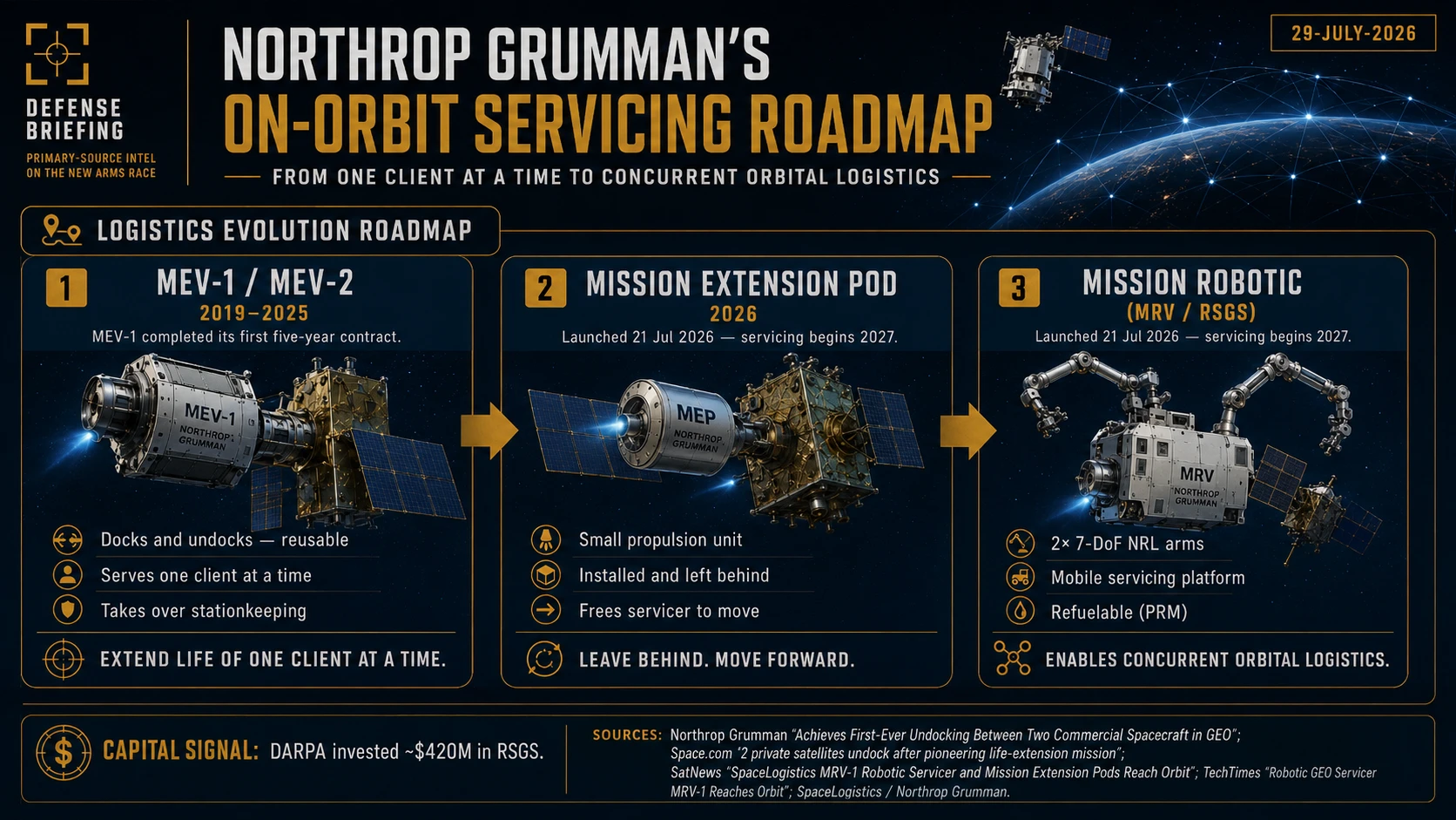
The architectural progression matters more than any single mission: attach and stay, install and leave, then move among customers. Graphic: Defense Briefing.
Northrop's officially identified tasks include robotic satellite inspection, relocation, repair, debris removal, upgrades, experimentation and in-space assembly.4 The vehicle also carries the first Passive Refueling Module (PRM), a docking and refueling interface standard approved by the Space Force that allows the servicer itself to be refueled on orbit and to perform what Northrop calls future sustained space maneuver missions.
Optus is the first publicly identified Mission Extension Pod customer. The pod is intended to extend the life of Optus D3, a Ku-band spacecraft launched in 2009 serving Australia and New Zealand.9 Northrop states the pod provides roughly six years of life extension for a typical 2,000-kilogram GEO satellite.11 Intelsat provided the operational heritage for the broader business model through Northrop's earlier Mission Extension Vehicles.
MRV is using electric propulsion to raise its orbit. SpaceLogistics expects a transit of roughly ten months to a year before it reaches GEO and begins proximity demonstrations.11 It is launched, but it is not yet an operational robotic mechanic working in the GEO belt.
The same sensors, autonomy, proximity operations and robotic manipulation that support cooperative repair also create latent military utility. Debris removal, which appears on Northrop's own task list, is non-cooperative capture described in civil terms. That does not mean MRV has demonstrated non-cooperative capture of an unwilling target or holds an offensive mission. It means the underlying technology cannot be neatly separated into civilian and military categories. Cooperative servicing of a prepared client whose geometry and consent are known is a different problem from attempting to control a tumbling, non-cooperative or actively evasive object.
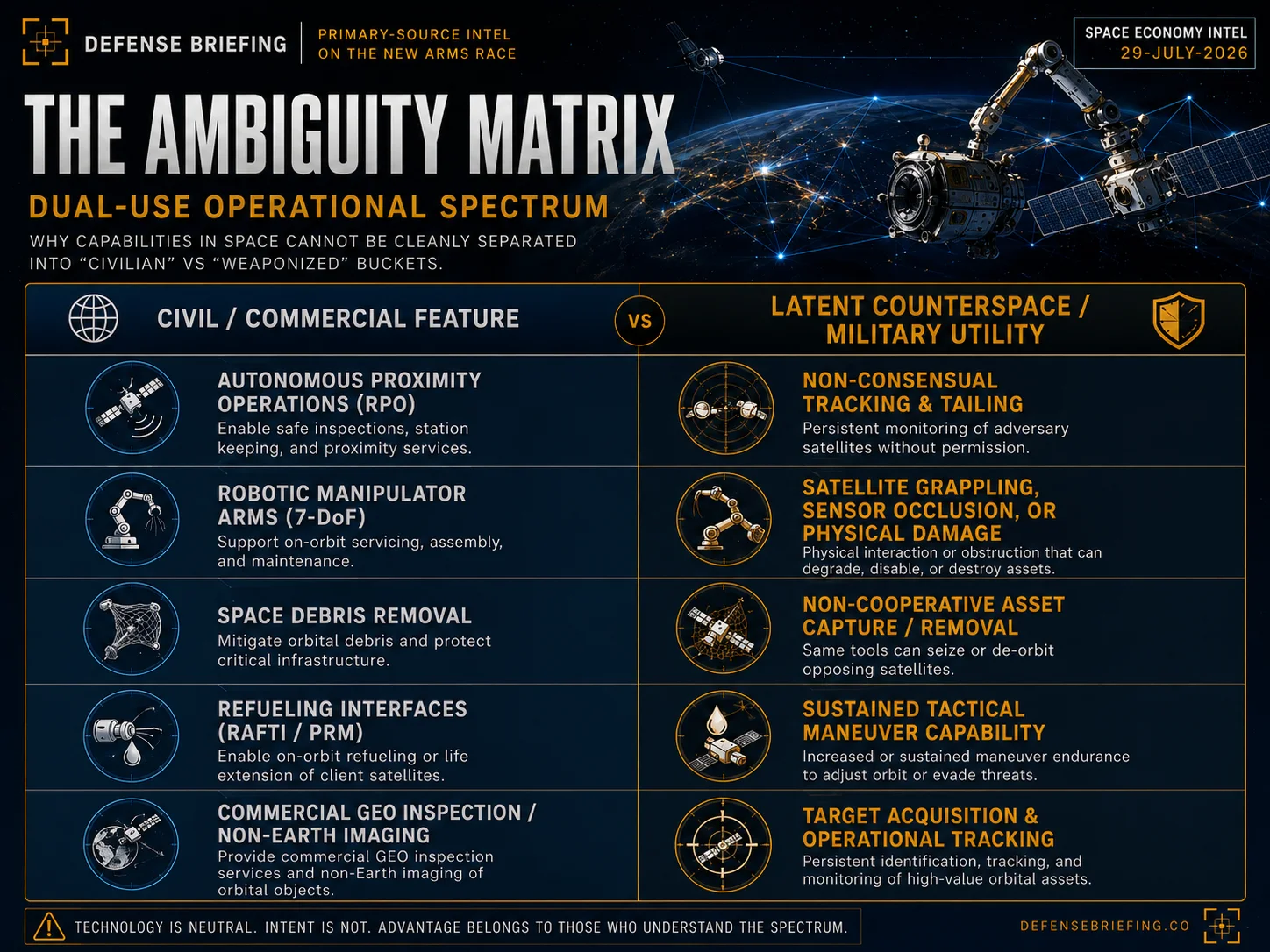
Every capability that makes a servicer useful to a paying customer makes it useful to a targeteer. Graphic: Defense Briefing.
The architectural progression is more important than any single mission. The Mission Extension Vehicle attaches and stays. The Mission Extension Pod is installed and left with the customer. The Mission Robotic Vehicle moves among customers. Refueling allows the servicing vehicle to remain useful beyond its original fuel load.
We read the filings, the fact sheets and the orbital elements so you do not have to.
Subscribe FreeV. The Asymmetry
The two spacecraft illustrate different forms of access rather than a clean mirror image.
Shijian-31 potentially increases repeated access to information across the GEO neighborhood. MRV increases physical access to cooperative spacecraft already there. One is already in its unusual orbit. The other remains in transit for the better part of a year. Neither capability cancels the other.
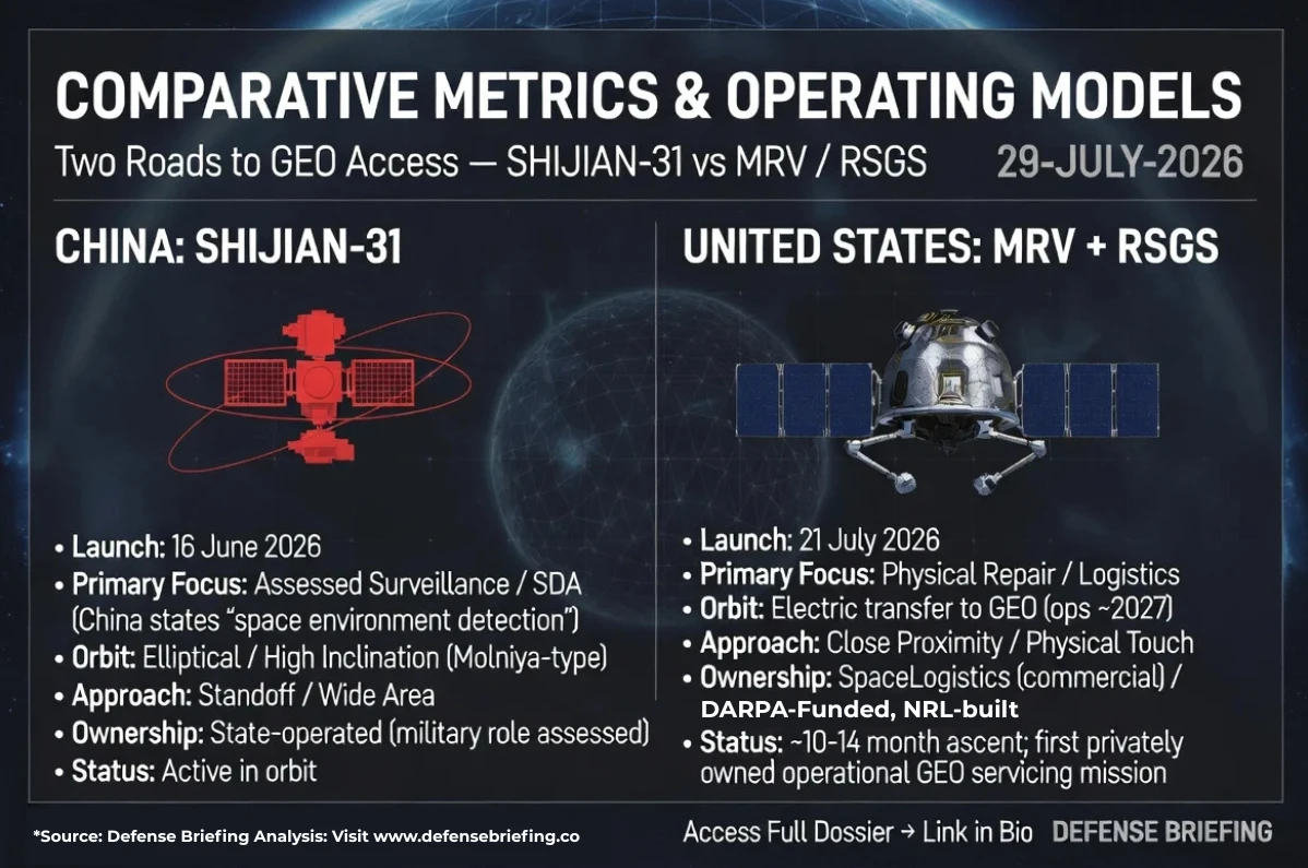
Two roads to GEO access. One state-operated and already on station, one commercially operated and still climbing. Graphic: Defense Briefing.
China has placed an undisclosed spacecraft in an orbit that repeatedly exposes it to the GEO belt. America has launched a commercial spacecraft designed to work directly on cooperative GEO satellites. Both reduce the old distinction between observing, servicing and potentially contesting objects in orbit.
One caution against reading this as opacity versus transparency: GSSAP's maneuvers and payload characteristics are classified, and the United States publishes very little about what those satellites collect. The asymmetry described here is that of the operating model, not of disclosure.
VI. The Economics of Optionality
The older GEO model treated end-of-life as a hard deadline. When stationkeeping fuel was exhausted, a functioning payload was often discarded. Servicing changes the decision calculus without requiring a clean accounting shift from capital expenditure to operating expenditure.
A Mission Extension Pod is a physical asset, customer-owned and customer-controlled, installed on another satellite. Some servicing may be sold as a commercial service, but the real economic value is optionality: delay a replacement satellite, preserve revenue from an existing orbital position, recover from certain mechanical faults, move a satellite to a different longitude, add propulsion without replacing the payload, spread one servicer across multiple clients and avoid discarding a functioning payload solely because propellant is depleted.
For investors, the near-term read is positional rather than financial. DARPA invested approximately $420 million in the RSGS program, which is the clearest public figure attached to the capability.12 Northrop Grumman (NYSE: NOC) has disclosed no MRV contract value of its own, and servicing revenue is immaterial to company earnings today. Optus, a Singtel subsidiary, is the only publicly named pod customer of the three launched. What Northrop now holds is the RSGS operational heritage and the first refueling interface standard approved by the Space Force. That matters because the Space Force's Servicing, Mobility and Logistics portfolio is explicitly seeking orbital depots, reusable transfer vehicles, propellant distribution, inspection and repair, with an objective of sustained maneuver, reduced predictability and longer mission endurance. Owning the approved interface standard positions a company to compete for that work, and awards in the category are tracked in our Pentagon contract database.
Northrop is not the only company positioning against that portfolio. Momentus is building orbital transfer vehicles and hosted-payload services, and Redwire is building space infrastructure and in-space manufacturing capability. The competitive question over the next several years is whether servicing becomes a market with multiple credible suppliers or remains a single-vendor capability, which is the same structural question we examined in Transmission 003 on the prime contractor monopoly.
GEO resilience is no longer only about hardening a satellite against attack. It increasingly includes the ability to move, refuel, inspect, repair and reconstitute capability after something goes wrong. A robotic mechanic cannot necessarily repair a destroyed sensor or rebuild a shattered solar array. It improves resilience against fuel exhaustion and certain anomalies. It does not eliminate vulnerability.
Follow the money, hardware and standards shaping the space economy.
Get Orbital Intel FreeVII. No Agreed Keep-Out Zone
International law already governs and constrains activity in space. The Outer Space Treaty requires states to act with due regard for the interests of others and to consult when an activity risks harmful interference. The United Nations has issued voluntary long-term sustainability guidelines, and U.S. Space Command has published its own voluntary responsible-behavior tenets intended to reduce misunderstandings or miscalculations.1 None of these instruments, however, create a binding keep-out zone.
Two Outer Space Treaty provisions matter more than the lack of keep-out zones. Article VI holds states internationally responsible for all national space activities, including those of private companies, and requires continuous supervision of them. Article VII makes the launching state internationally liable for any damage caused by its space objects.
MRV is a commercial spacecraft owned and operated by Northrop Grumman, yet its payload is DARPA-funded and was built by a U.S. Navy laboratory. If it damages another spacecraft, the United States remains liable regardless of the commercial wrapper. That ambiguity is unique to the American model. Shijian-31 raises no parallel question because it is state-owned and state-operated end to end.
What is still missing is more specific: no universal binding standoff distance, no international consent standard for proximity operations, no agreed definition of hostile inspection, no automatic threshold at which observation becomes interference and no reliable method for proving intent before damage occurs.
The dangerous gap is not the absence of rules. It is the absence of clear thresholds for behavior that can shift from observation to interference without warning.
When does repeated observation from thousands of kilometers become operational preparation rather than ordinary space-domain awareness? And when does a servicing spacecraft's close approach become coercive if the target has not consented?
The Angle
For national security, the practical consequence is that GEO custody now requires continuous tracking of behavior rather than periodic tracking of position. Shijian-31 does nothing prohibited. It simply guarantees that a Chinese spacecraft will pass near a different segment of the belt every day, and the United States cannot currently characterize what it carries. Meanwhile the American answer to GEO predictability is splitting in two directions at once: proliferation into low Earth orbit through the architectures we cover in the PWSA explainer and the Space Development Agency explainer, and sustained maneuver in GEO through servicing and refueling.
For capital, the signal is not a contract award. It is a standard. Interface standards decide who gets to participate in a market before the market exists, and the Passive Refueling Module is now the approved one. Watch which spacecraft buses adopt it over the next two procurement cycles. That adoption curve, rather than any single servicing mission, is what would convert a demonstration heritage into recurring revenue.
Those questions are no longer theoretical. They now sit permanently in GEO. The answers will be written by the next close approach, not by another treaty conference.
Forward this to the analyst who still thinks geostationary orbit is a parking lot.
OPEN COLLECTION GAPS
- • Sensor type and aperture aboard Shijian-31.
- • Operating entity: China Aerospace Science and Technology Corporation subsidiary versus People's Liberation Army Aerospace Force tasking.
- • Whether the satellite has maneuvered since 16-JUN-2026 and in what direction.
- • The identity of the two non-Optus Mission Extension Pod customers.
- • Whether MRV's proximity-operations demonstrations will be publicly announced or conducted quietly.
Sources: Launch facts derive from China Aerospace Science and Technology Corporation via Xinhua and from Northrop Grumman's own launch release. Program structure and hardware detail derive from Northrop Grumman and the U.S. Naval Research Laboratory. Vulnerability findings derive from Government Accountability Office report GAO-26-107085 and from Headquarters U.S. Space Force Intelligence. All orbital characterization of Shijian-31 derives from public catalog elements as analyzed by Integrity ISR and reported by SpaceNews, and is labeled as third-party analysis throughout. The numbered list below is authoritative. No classified information was used and all material is publicly accessible.